
Mapping of multiple minerals in Gävleborg county
Since 2021, the Geological Survey of Sweden has been conducting an investigation focused on graphite, gold, cobalt, and base metals in the boundary zone between the lithotectonic units of Bergslagen and Ljusdal in Gävleborg County. The goal is to update the geological, geophysical, and geochemical data on selected mineralisations and to increase knowledge about their formation processes.
The project aims to demonstrate the geological processes that contribute to ore formation. This is done by examining various alterations, mineralisations, their relation to the stratigraphy and structures, and the structural framework and evolution of the bedrock. We also use 3D modeling to show how mineralisations and the surrounding bedrock are built up.
The investigation is conducted in four separate sub-projects, each with its specific conditions and possibilities.
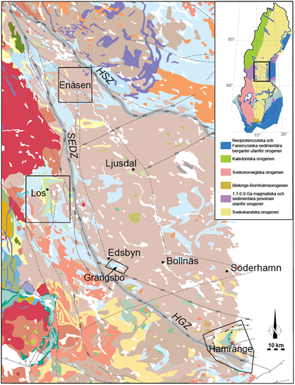
The map shows the bedrock in and around the Ljusdal lithotectonic unit, with black polygons for the four sub-project areas. The thick grey lines follow the deformation zones that limit the unit: HSZ = Hassela shear zone, SEDZ = Storsjön-Edsbyn deformation zone, HGZ = Hagsta gneiss zone. The maps are modified from the Bedrock Map 1:1 million. The inset map shows the larger lithotectonic units in Sweden. The black rectangle shows the location of the main map, and the grey lines limit the Bergslagen (B) and Ljusdal (L) lithotectonic units.
Investigation of the sulfide deposits in Enåsenfältet
In the Enåsen gold-copper mine, which was in operation between 1984 and 1991, the ore minerals are disseminated in quartz-sillimanite gneiss. The occurrence has been classified by SGU as a gold deposit of national interest.
Southeast of the Enåsen gold-copper mine, there is a zone with deposits that is referred to as Enåsenfältet:
|
Deposit |
Substance |
|
Flomyra |
Copper and gold |
|
Enåsgruvan |
Copper and silver |
|
Ramsjögruvan, Nymyran and Felberget |
Iron sulfide |
|
Långtjärnen |
Zinc |
North of Enåsen, there is also Malsjöbodarna, which is a copper and iron sulfide occurrence.
Mineralised samples from outcrops, waste rock, and drill cores from all deposits in the area are analyzed. Around the Enåsen gold-copper mine, there are numerous drill holes, and many chemical analyses have been performed. A 3D model is made over the drilled part of Enåsen with the support of geophysical data. The work began in 2021.
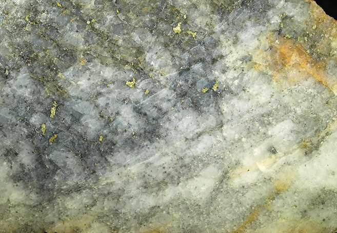
Closeup showing a sawn slab with gold-tellurium-bismuth-copper-rich ore from the Enåsen gold-copper mine. Image width approximately 4 cm.
Photo: Erik Jonsson.
Formation of the Los copper-cobalt mineralisations
The Los cobalt mine was in operation for over 30 years in the mid-1700s. The ore appears partly in a fracture zone up to 30 centimeters wide in metabasalt and can be traced for at least about 90 meters.
In the Los area, there are several mining fields, and 43 mineralisations of six different types are known:
|
Deposit |
Substance |
|
Losfältet and Ställstensbergets koppargruvor |
Copper |
|
Los koboltgruvor |
Copper, cobalt, bismuth, nickel and arsenic |
|
Nätsjögruvorna |
Copper, lead, zinc, silver and gold |
|
Losfältet |
Copper, nickel and cobalt |
|
Risbergets gruvor |
Iron sulfide |
|
Dåasgruvefältet, Risbergets gruvor and Björkbergs gruvor |
Iron oxide |
The planned activities include collecting mineralised samples from outcrops, waste rock, and drill cores from deposits in the area and better characterizing these through petrography, lithogeochemical analysis, and isotope analysis. Ore mineralogical observations and data from historical samples from the Los mines will also be collected. Structural geological investigations and geophysical measurements are carried out to enable 3D modeling in selected areas together with drill core data. This work began in 2022.
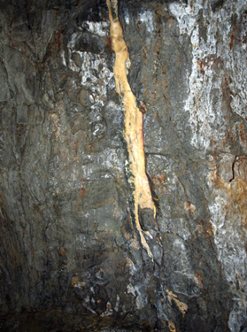
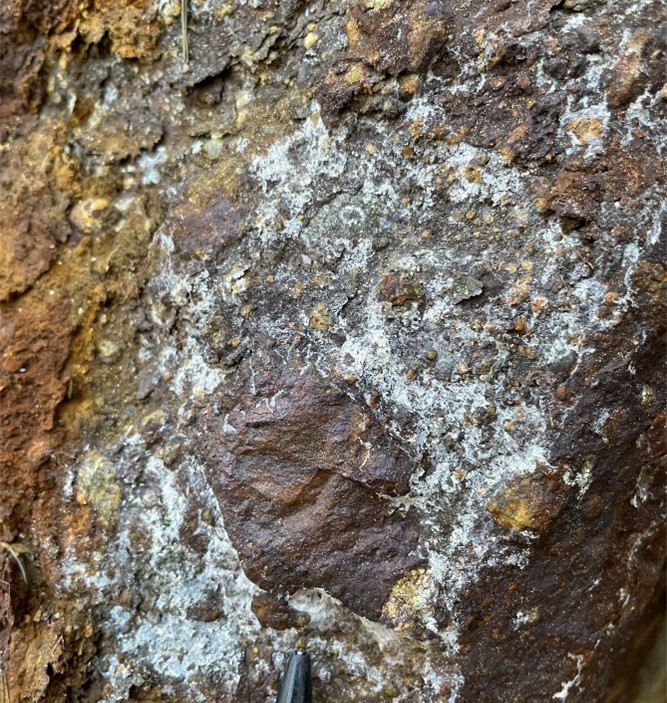
Mineralized calcite vein from the Los cobalt mines.
Photo: Erik Jonsson
Investigation of the sulfide deposits in Hamrånge group
In the Hamrånge area, which has well-preserved volcanosedimentary bedrock, there are 47 known mineralisations. These include sulfide-copper (± arsenic, gold, silver, lead, zinc, molybdenum, and iron), as well as gold, iron oxide (± arsenic, gold, silver, copper, zinc, and lead), and pegmatite containing lithium, tantalum, and niobium. For 17 of these, partial chemical analyses are available in the mineral resource database.
Several of the area's sulfide, precious metal, and iron occurrences are being investigated for the content of potential innovation critical elements in samples from outcrops, waste rock, and drill cores. If elevated levels of such elements are found, it may lead to more in-depth mineralogical and chemical investigations.
Exploration permits exist for lithium (Tasman Metals AB) and for lithium and tantalum (Leading Edge Materials). This project does not investigate this type of mineralisation. There are over 30 drill holes concentrated in an area of about 1 square kilometer around the precious metal-sulfide occurrence Rörmyran. There are good prerequisites for creating a 3D model here. Geophysical profile measurements, petrophysical sampling, and modeling are carried out. This work began in 2023.
Sulfide mineralization Kummeludden on the northwestern tip of Gåsholmen in the Hamrånge area.
Photo: Stefan Luth
Ore potential for the Grängsbo zinc-copper mineralisation
In the Grängsbo area, there are nine sulfide mineralisations with copper, zinc, and gold in fault breccia. There are results from the 1980s from bedrock mapping, ground magnetic field measurements, slingram, and four drillings. The proposed structure is an overturned synform; the mineralisation does not go deeper than the fold hinge. However, the hinge zone itself has not been drilled, but its distribution on the bedrock surface is interpreted from slingram data.
The mineralisation was previously interpreted as a stratiform complex mineralisation in a sedimentary environment, but after the drilling effort, it was reinterpreted as a fault-bound breccia mineralisation. In the current project, we will test and evaluate the existing model through structural geological investigation, drill core logging, and geophysical measurements. Petrophysical samples are taken to support geophysical and geological 3D modeling. Knowledge of the mineralisation is expanded through microscopic examination and chemical analyses of mineralised samples from outcrops, waste rock, and drill cores. If elevated levels of critical innovation elements (e.g., indium, gallium, or germanium) are found, it may lead to more in-depth mineralogical and chemical investigations. This work began in 2024.
Rich sulfide mineralization in fault breccia from Grängsbo.
Photo: Stefan Luth
Last reviewed 2025-02-28