

Waste pile at the Sällberg mines, Skälö, ca. 20 km south of Västervik.
Mapping in northern Småland and Östergötland
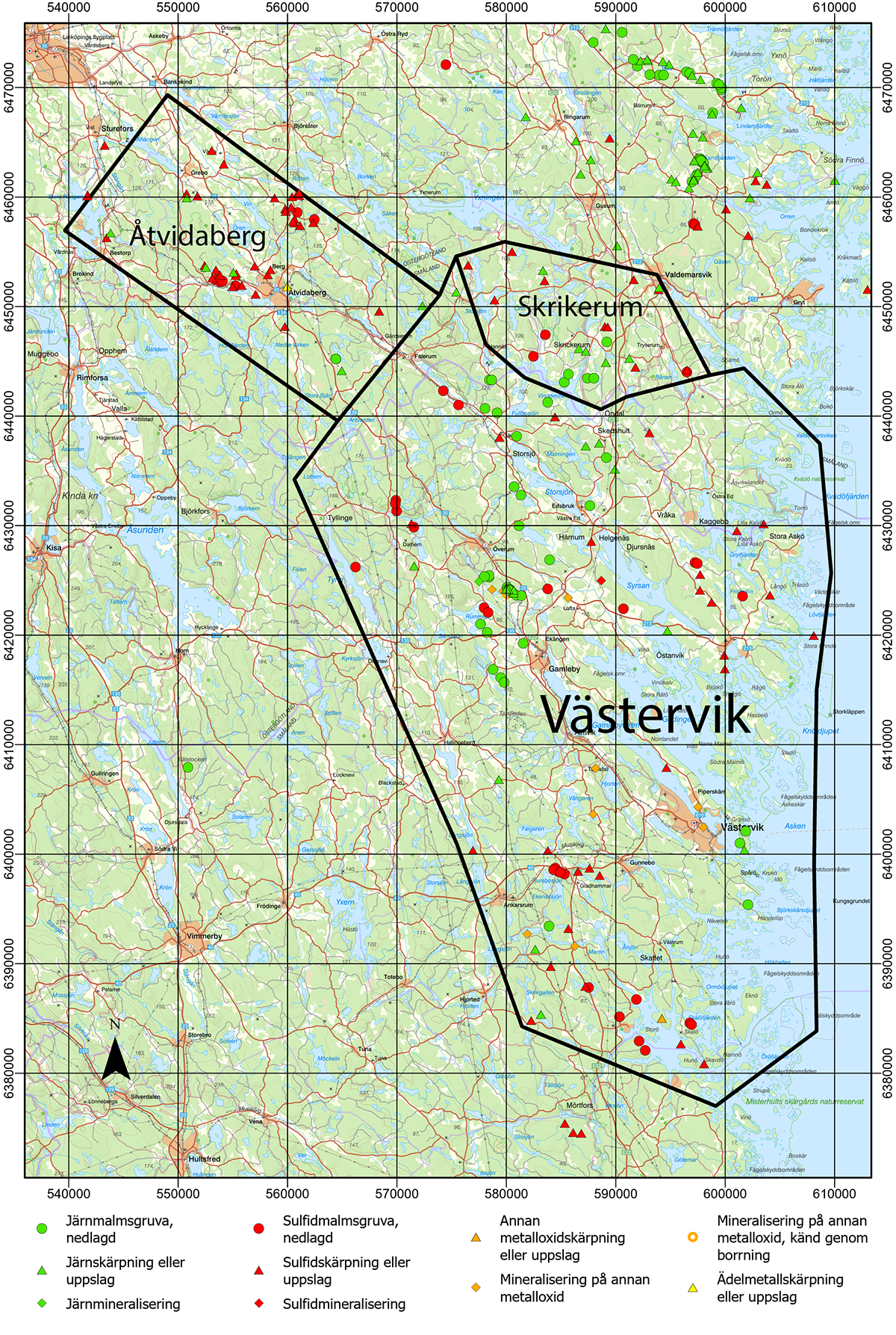
The Geological Survey of Sweden (SGU) launched a mapping project in 2023 focused on northeastern Småland and southeastern Östergötland. The project is divided into three subareas: Skrikerum, initiated in 2023, Västervik, which started in 2024, and Åtvidaberg, scheduled to start in 2025 or 2026.
To general goal of the project is to upgrade SGU’s bedrock map database to a more detailed scale, as well as to sample and analyse the mineralisations in the area with a focus on so-called critical and strategic raw materials. Geological, geochemical, and geophysical data collected during the project are continuously made available in SGU’s databases. Below are brief descriptions for each subproject, including preliminary results.
Map showing the three subproject areas, including known mineral resources and mineralisations. ”Other metal oxide” in this case mainly refers to uranium or rare earth elements occurrences. Basemap from Lantmäteriet, one grid square equals 10 x 10 km.
Subarea Skrikerum
In the Skrikerum subarea, previously known mineralisations of iron, copper, and selenium have now been reassessed with a focus on critical and strategic raw materials. Fieldwork started in 2023 and was concluded in 2024, yielding a total of 83 observations now included in SGU’s database Bedrock observations. A total of 35 samples were collected from outcrops and waste piles for lithogeochemical analysis. Additionally, petrophysical measurements were performed on 78 samples, providing data on the physical properties of the rock types, including density, magnetic susceptibility, and electrical conductivity.
Map showing the subproject area Skrikerum. Observations made in 2023 are marked with red dots, and 2024 year’s observation marked with blue dots. Basemap from Lantmäteriet, one grid square represents 5 x 5 km.

Preliminary findings reveal anomalous concentrations of copper, gold, nickel, cobalt, selenium, tellurium, manganese, and rare earth elements in several of the sampled mineral occurrences. An ultramafic rock sampled near Larum and Kvarnvik shows high concentration of MgO (26.0%), anomalous levels of chromium (2,200 ppm) and nickel (1,040 ppm, predominantly in sulphides), as well as elevated boron concentrations. This mafic body also corresponds to the most prominent gravity anomaly in the Skrikerum subarea. Additionally, skarn with garnet and magnetite sampled from the Skårsjö minefield shows anomalous concentrations of rare earth elements (433 ppm REE+Y).

Waste rock from a copper-nickel-iron mineralisation east of Karlsmåla. Anomalous concentrations of copper (1.56%), cobalt (599 ppm), nickel (1,650 ppm), sulphur (14.5%), selenium (32.7 ppm), tellurium (3.96 ppm), elevated concentrations of gold (0.16 ppm), bismuth (1.21 ppm), palladium (0.063 ppm), rhenium (0.038 ppm) and thallium (1.59 ppm). The mineralisations consist of pyrrhotite, magnetite, chalcopyrite and other sulphide minerals, hosted in a metabasaltoid (6452503/591624). Photo: Dick Claeson, SGU.
In 2024, geophysical measurements were carried out at 20 outcrops. Magnetic susceptibility was recorded for all rock types at all of these outcrops. Gammaspectroscopy measurements were conducted at 7 of these outcrops. Ground measurements (magnetometry) were performed along profiles at six localities, two of which are near historic mines, covering a combined profile length of ca. 24 km. New gravity measurements were also collected in the area during 2024. In addition, airborne geophysical surveys, including magnetic field, gammaspectroscopy and two-transmitter VLF, were conducted in 2023, with the resulting data released in 2024. These datasets will be integral as support for geological interpretations and modelling.
Map showing the subproject area Skrikerum with geophysical observations conducted 2023–2024. Basemap from Lantmäteriet, one grid square equals 5 x 5 km.

Further analysis and interpretations of the collected data are now underway, based on which revisions are made in SGU’s bedrock map database. The results will also be summarised and presented in an SGU report, scheduled for publication in fall 2025.
Subarea Västervik
The Västervik subproject includes known occurrences of critical raw materials, such as the rare earth element deposit at Olserum and the cobalt-rich sulphide ores at Gladhammar. However, most of the area’s mineralisations are yet to be sampled and analysed using modern methods. A key objective of this project is to understand the formation processes and timing of these mineralisations during the area’s almost two billion years long geological history. Such knowledge could provide valuable insights to guide future exploration in the area.
Map of subproject area Västervik. Bedrock observations made in 2024 are marked with pink dots. Base map from Lantmäteriet, one grid square equals 10 x 10 km.

In the spring of 2024, initial sampling was conducted of most of the area’s known mineral occurrences. From June to September, bedrock mapping was performed in the northern parts of the project area (see map). A total of 839 locations were documented for rock types and other geological data, information which has been incorporated in SGU’s Bedrock observations database. Additionally, 74 samples were collected from outcrops and waste piles and sent for full geochemical characterisation. Another 77 samples were collected for petrophysical measurements (density, magnetic susceptibility and electrical conductivity). Five samples were taken for radiometric age determination. Mapping and sampling will continue in 2025.
Analytical results from the sampling of known mineral occurrences show elevated, and in some cases notably high concentrations of among others (maximum values): rare earth elements (14.5%), phosphate (7.98%), thorium (4.15%), copper (4.09%), titanium (2.73%), manganese (0.63%), uranium (0.40%), zirconium (0.31%), lead (0.18%), vanadium (708 ppm), tungsten (627 ppm), chromium (755 ppm), cobalt (373 ppm), bismuth (237 ppm), and gold (0.47 ppm). All these results are available in SGU’s Lithogeochemistry database.

A vein of biotite, magnetite, fluorapatite and xenotime-(Y) in a strongly foliated granite. Olserum. Photo: Stefan Andersson.
In the northwestern part, geophysical measurements were carried out at 50 outcrops with magnetic susceptibility recorded for all. Gammaspectroscopy measurements were conducted at 40 of these outcrops. New gravity measurements were performed in the northern part of the area in 2024. The aim of the geophysical fieldwork was to characterise the rock types in the area to support the interpretation of the new airborne geophysical data collected in 2023 and released in 2024 (magnetic field, gammaspectroscopy and two-transmitter VLF).
Map showing the subproject Västervik with geophysical observations conducted in 2024. Black dots: outcrops with measured magnetic susceptibility, red pentagons: samples for petrophysical analysis, yellow pentagons: outcrops with gammaspectrometry measurements. Base map from Lantmäteriet, one grid square equals 10 x 10 km.

Delområde Åtvidaberg
Around Åtvidaberg, known copper mineralisations exists. However, these have largely not been sampled and analysed using modern methods that target a wide range of metals and elements. In some cases, rare earth elements have been detected in association with iron mineralisations, but it remains unclear to what extent the critical or strategic raw materials are present in the area. The primary focus of this subproject will be to investigate the area’s mineralisations and conduct bedrock mapping of the surrounding area. The work is currently scheduled to begin in 2025 or 2026.
Last reviewed 2025-01-08