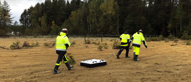
The SGU’s ground-penetrating radar system (GPR ) in use at the Källfallet site. An operator can pull the system and operate the data acquisition.
Photo: Mehrdad Bastani.
Unique test of geophysical methods for mapping mine waste
In a new report, the Geological Survey of Sweden (SGU) shows how geophysical surveys can help increase knowledge about historical mine waste. Different geophysical methods have been used on different types of tailings repositories, which has provided a unique basis for evaluating them.
Secondary resources from mine waste can possibly contribute to the supply of the metals and minerals needed for the energy transition. Geophysical surveys are an important part of mapping where these resources can be found and in what quantities.
In a project at SGU, eight types of tailings repositories in the Bergslagen mining distict have been investigated using different geophysical methods, which has provided an important basis for evaluating the suitability of different methods under different conditions.
– The purpose of the surveys was to create 3D models that can help us better understand the distribution of the mine waste in the tailings repositories, as well as to estimate the amount of waste. Our report also describes and explains the differences between the geophysical methods we used and provides an assessment of how they can be applied, says Lena Persson, geophysicist.
The selection of test sites was based on previous studies and most of the waste was residual products from the mining of iron ore, but also other elements such as tungsten and copper. The test sites are located within five mining areas in Bergslagen in central Sweden.
Within the project, SGU has used various geophysical methods to determine the resistivity, i.e. resistance to conducting electric current, of the tailings and as well tested induced polarization, which provides a measure of the electrical chargeability (IP effect). At all the investigated sites, the extent and depth of the tailings could be determined using models based on investigations of the resistivity.
– The variations in resistivity in the tailings can mainly be explained by variations in water saturation and grain size. Variations in grain size can in turn often be linked to variations in metal content. At one of the of the tailings repositories, we also observed a correlation between metal content (iron) and IP effect, says Lena Persson.
The geophysical surveys were carried out as part of a governmental directive on sustainable extraction of metals and minerals from secondary resources. The work is intended to contribute to the transition to a more circular and resource-efficient economy. The directive was reported in full in 2023.
Read the full report here:
Secondary resources directive. Characterisation of mine tailings in the Bergslagen region using geophysical methods, SGU-rapport 2025:05
Last reviewed 2025-04-29
